- Mar 21, 2025
-
Thinking of Buying Land? Don’t Get Stuck With a Plot That Has No Road Access!
We get it—buying land is exciting! But here's the harsh reality: many buyers end up with plots without proper road access, and the legal headache that comes with it can be a nightmare.
Before you sign the dotted line, it’s CRUCIAL to check whether the land has a legal and accessible pathway connected to the main road. No one wants to invest in a “landlocked” property that can’t even be reached by vehicle!
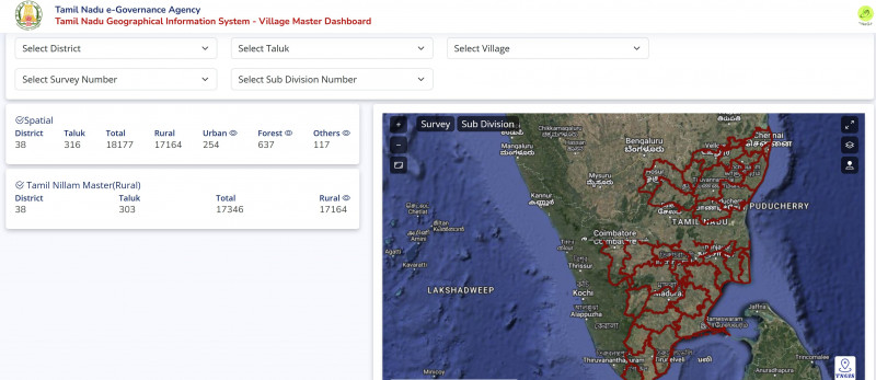
✅ Good news: The TN GIS Village Master Dashboard makes this process easy, fast, and free.
🚀 What is the TN GIS Village Master Dashboard?
The Tamil Nadu GIS Village Master Dashboard is a digital mapping tool created by the Tamil Nadu Survey and Settlement Department. It allows you to:
- View land survey maps and boundaries
- Check land classification (residential, agricultural, etc.)
- Verify road access and connectivity
- Confirm legal paths to and from the plot
It’s a must-use tool for any land buyer in Tamil Nadu.
🛠️ Step-by-Step Guide: How to Use the TN GIS Village Master Dashboard
🔗 Access the Dashboard:
Go to: https://tngis.tn.gov.in/apps/village_dashboard/
✅ Step 1: Select Your District & Taluk
- On the left side of the dashboard, choose:
- District (e.g., Tiruvannamalai)
- Taluk (e.g., Chengam, Kilpennathur, etc.)
✅ Step 2: Choose Your Village
- Pick the village from the dropdown where your plot is located.
- The system will load the village map with survey boundaries.
✅ Step 3: Enter the Survey Number
- Use the search bar to type the Survey Number of the land you're interested in.
- The map will highlight the exact plot on the map.
🚗 Step 4: Check for Road Access
- Zoom in on the plot and observe the colored lines that indicate roads and pathways.
- Main roads, village roads, and cart tracks are usually marked clearly.
- Make sure the plot is connected to a public or government pathway, not just surrounded by private lands.
✅ If the plot touches a panchayat road, highway, or village road, it has legal access.
❌ If it’s landlocked, and no road touches the plot, avoid the deal or speak to a legal advisor.
📜 Step 5: Understand Land Classifications
Hover or click on the plot to view additional info:
- Type of land (e.g., agricultural, residential, poramboke, water body, etc.)
- Survey boundaries and neighboring plots
- Whether the land is under any government reservation or restrictions
✅ You want land that is marked as “Nanjai” or “Punjai” (usable land) with clear access routes.
❌ Avoid “poramboke” lands or plots surrounded by lands without declared road access.
🧠 Why Road Access Is Non-Negotiable
🚫 Without road access:
- You can’t legally construct or get building plan approval
- No vehicle access, which affects usability
- Banks may refuse loans for construction
- You’ll face legal disputes with neighbors or local authorities
- Resale becomes difficult or nearly impossible
✅ With legal road access:
- Smooth property registration and resale
- Easy access for utilities (water, EB, sewage)
- Can build and use the land legally
- Better appreciation and investment value
🔍 Quick Tips Before Buying Any Plot:
- Always verify road access using the TN GIS Village Dashboard.
- Cross-check with the Field Measurement Book (FMB) and Patta/Chitta.
- Visit the land physically to confirm what you see online.
- Ensure road shown on GIS is a public or panchayat road, not a private path.
- Consult a local surveyor or VAO for clarity if unsure.
📝 FAQs
1. Is TN GIS data 100% accurate?
It’s reliable for general verification, but always confirm with physical inspection and local records.
2. Can I apply for road access if my land is landlocked?
You may apply legally for a right of way, but it involves a lengthy process and neighbor approval.
3. Does DTCP approval guarantee road access?
Not always! Some layouts may be approved without physical connectivity. Always check the actual road presence on site.
✅ Final Thoughts: Don’t Let Your Dream Plot Become a Legal Nightmare
Buying land is one of the biggest financial decisions you’ll make. So don’t rush it.
Use the TN GIS Village Master Dashboard to:
🔎 Verify survey boundaries
🚗 Confirm legal road access
📌 Understand land classification
Only then should you move forward with confidence and clarity.
📍 Access the Dashboard Here:
👉 https://tngis.tn.gov.in/apps/village_dashboard/
💡 Pro Tip: Always take screenshots and save documents when doing online checks — it’ll come in handy during registration or disputes.

Comments :
Currently, there are no comments in this post. Be the first person to comment on this post.